Quantification of felt ground motion
The macroseismic sensor (MSS) network is used to answer two main questions which generally arise after a felt ground motion:
What was the source of the groundmotion? An earthquake, a quarry-blast, nearby construction site or heavy traffic?
Was there a potential risk for life and the possibility for damages to buildings, fixtures and infrastructure?
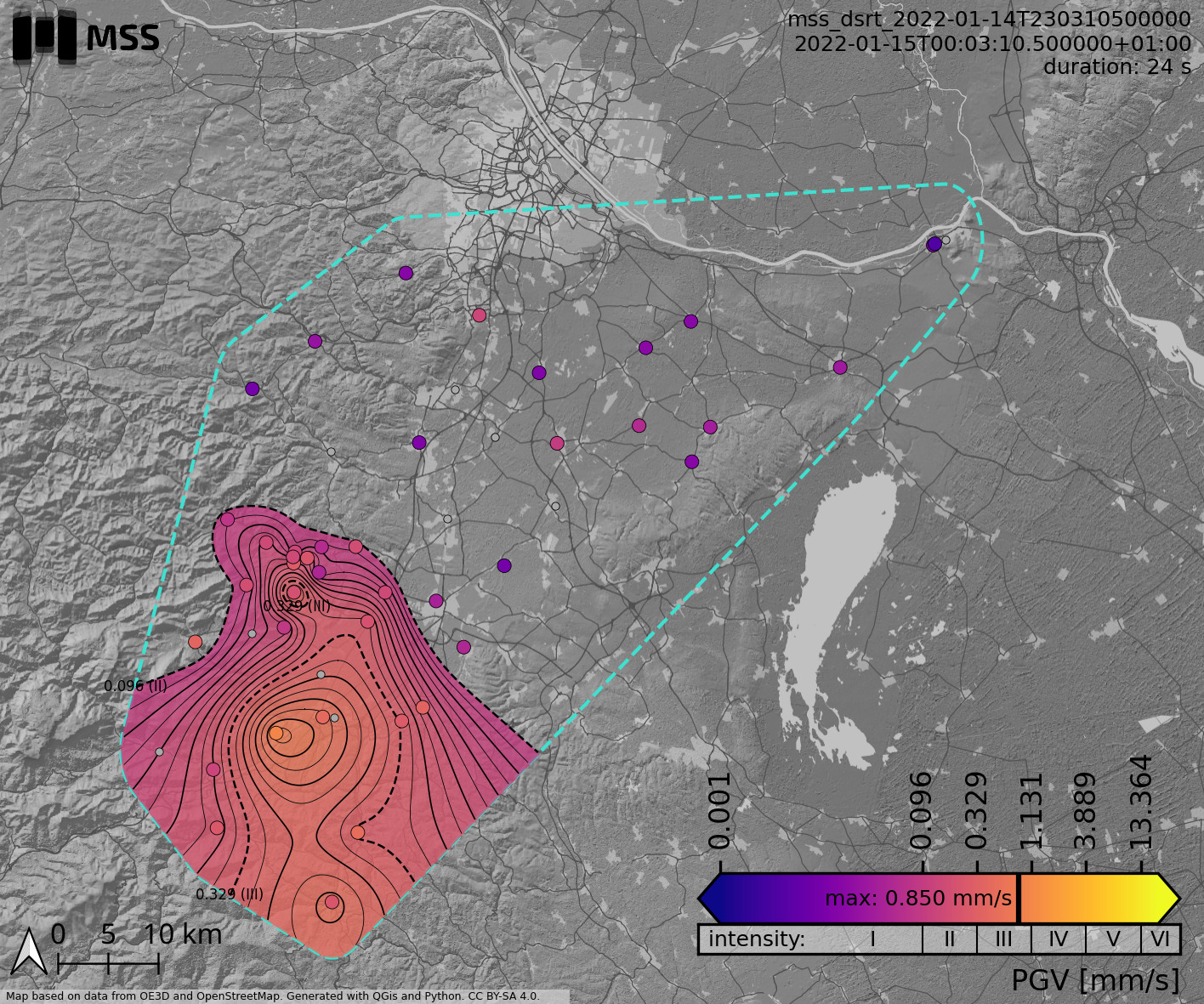
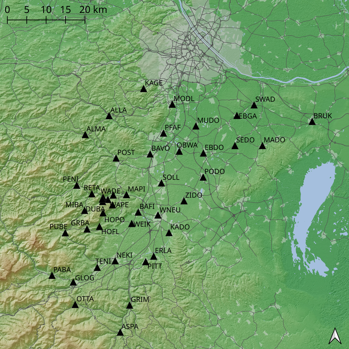
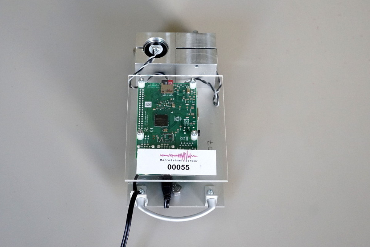
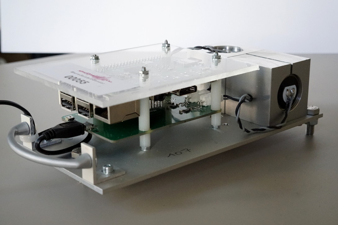
The MSS network is a dense layout of seismic low-cost sensors in populated areas. Currently, 45 stations have been deployed in the southern part of the Vienna basin. The sensors deliver the peak ground velocity (PGV). The processing of the data focuses on a fast discriminate between regional sources (e.g. earthquake or quarry-blast) or local events like construction work or traffic.
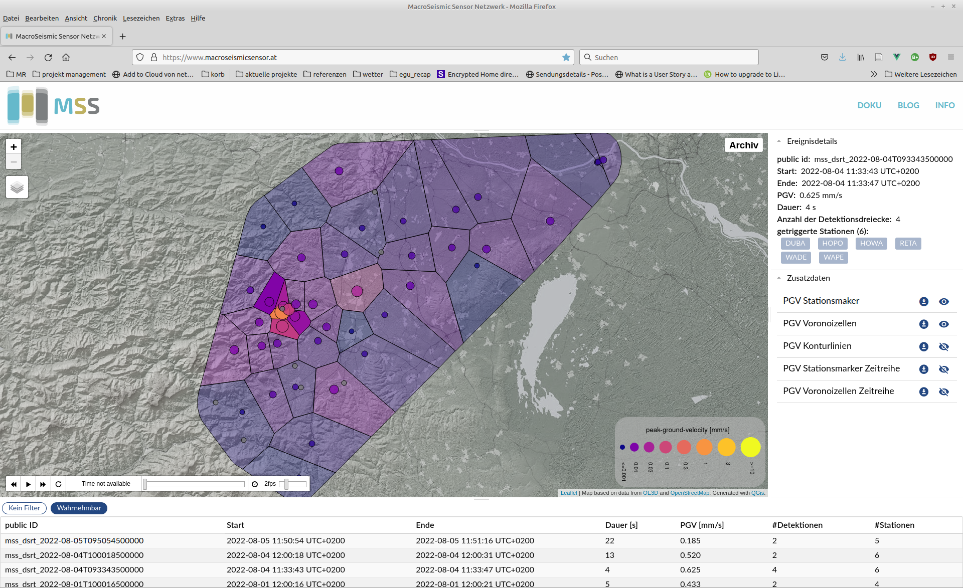
The information is communicated to the public and local authorities using the homepage http://www.macroseismicsensor.at/.
Visual Documentation
Project Metadata
-
Related Publications
Journal Articles
- E. Brückl, P. Carniel, S. Mertl, and R. Meurers, “Das Macroseismic Sensor Projekt,” Österreichische Zeitschrift für Vermessung & Geoinformation, vol. 109, no. 3, pp. 114–130, 2021.https://www.ovg.at/de/vgi/ausgabe/1301/
- E. Brückl, “Graphical Location of Seismic Sources Based on Amplitude Ratios,” Seismological Research Letters, vol. 90, no. 2, pp. 784–789, Mar. 2019.http://doi.org/10.1785/0220180216
- E. Brückl, K. Filz, R. Hochwartner, S. Mertl, G. Stickler, and S. Zöhling, “Monitoring von Sprengerschütterungen mit seismischen „low-cost‘ Sensoren,” BHM Berg- und Hüttenmännische Monatshefte, vol. 164, no. 10, pp. 431–437, Oct. 2019.http://doi.org/10.1007/s00501-019-00892-z https://doi.org/10.1007/s00501-019-00892-z
- E. Brückl, P. Carniel, S. Mertl, and R. Meurers, “Seismological Data Acquisition and Analysis within the Scope of Citizen Science,” in Earthquakes, IntechOpen, 2021.http://doi.org/10.5772/intechopen.95273 https://www.intechopen.com/chapters/74466
- Stefan Mertl, “MSS Outreach - Endbericht - Call 14 - Projekt ID 4547,” Mertl Research GmbH, Project Final Report, 2021.https://www.netidee.at/sites/default/files/2021-05/prj4547_Call14_Endbericht_V04.pdf
- E. Brückl, J. Brückl, E. Umnig, and R. Weber, “Schools & Quakes Abschlussbericht,” TU Wien, Department für Geoinformation, Abschlussbericht APA 05/173, June 2017.https://www.oeaw.ac.at/geok/texte/sq_endbericht.pdf
- K. Ableitinger, H. A. Fock, C. Hackenberger, A. Kölbl, and S. Polydor, “MacroSeismic Network,” Diplomarbeit, TGM - HTBLuVA Wien XX IT Abteilung, 2016.
- E. Brueckl et al., “Design and first tests of a Macroseismic Sensor System,” 2017.https://meetingorganizer.copernicus.org/EGU2017/EGU2017-6418.pdf
- M. del Puy Papi Isaba and Ewald Brückl, “Robust method to detect and locate local earthquakes by means of amplitude measurements.,” 2016.https://meetingorganizer.copernicus.org/EGU2016/EGU2016-10354.pdf
- E. Brückl et al., “Scientific goals of SCHOOLS & QUAKES,” 2015.https://meetingorganizer.copernicus.org/EGU2015/EGU2015-3401-4.pdf
- Related Projects
-
Duration
The project started October, 2017 and is still running.
Related Posts
-
20 stations have been added to the MSS network. › MSS network extended
With some major effort of Ewald Brückl and Peter Carniel, the MSS network has been extended by 20 stations. It now consists of 45 stations sending seismic data in near real-time. Read More ›
-
20 Stationen wurden dem MSS Netzwerk hinzugefügt. › MSS Netzwerk erweitert
Mit dem starken Einsatz von Ewald Brückl und Peter Carniel wurde das MSS Netzwerk um 20 Stationen erweitert. Es besteht nun aus 45 Stationen, die seismische Daten in annähernd Echtzeit senden. Read More ›
-
Further extension of the MSS network funded by the government of lower Austria. › Funding for MSS granted
The government of Lower Austria granted the funding for a one-year project to extend the MSS network with 25 more stations and to improve the near-real time data transmission and visualization. Read More ›
-
Erweiterung des MSS Netzwerks › Zusage einer MSS Projektförderung
Wir erhielten von der niederösterreichischen Landesregierung eine Zusage für eine einjährige Projektfinanzierung für die Erweiterung des MSS Netzwerks und für die Verbesserung der annähernd Echtzeit Datenübertragung und -visualisierung. Read More ›
Project Timeline
July 2022
The Stadtgemeinde Hainburg joined the supporters of the MSS network as a sponsor.
February 2022
With the Baumit GmbH and the Zentralanstalt für Meteorologie und Geodynamik we could allure two important financial partners for the MSS Network.
May 2021
Completion of the netidee project MSS Outreach. Within the project a substantial improvement of the online visualization of the MSS data was accomplished.
November 2019
Funding granted by netidee for the MSS Outreach project.
June 2019
Finalization of the deployment of 20 additional units. The MSS network has been extended to 45 stations.
October 2018
Funding of the extension of the Macroseismic Sensor network with additional 25 units and the improvement of the data acquisition and processing software regarding near-realtime application. The funds are granted by the government of Lower Austria.
February 2018
Funding of an automated processing of recordings of quarry blasts at the quarry Dürnbach in cooperation with Baumit GmbH.
June 2017
Finalization of the deployment of 25 MacroSeismic Sensors in the southern part of the Vienna basin within the framework of Quake Watch Austria, Schools & Quakes and additional funding by the government of Lower Austria.
October 2014
Start of the development of the MacroSeismic Sensors within the framework of the QuakeWatch Austria project. QuakeWatch Austria was a citizen science sub-module of the Sparkling Science project Schools & Quakes.
Supported by